A Place-Name Walk Along a Mountain Valley
A place-name walk along a mountain valley helps you read local language, land use, and uncertain map labels without mistaking a map’s silence for the whole story.
What can a place-name walk along a mountain valley tell you that the contour lines cannot? Start with the words printed beside a stream, pasture, or stand of trees: they offer clues to how people have described and remembered the valley, even when the map cannot explain a name’s origin.
This is a close reading of language, not a route-planning exercise or a hunt for the “correct” label. Keep observations separate from guesses. A name might refer to a feature’s shape, a local story, or a word whose meaning has shifted; the printed label alone rarely settles which.
Choose a map and set a narrow focus
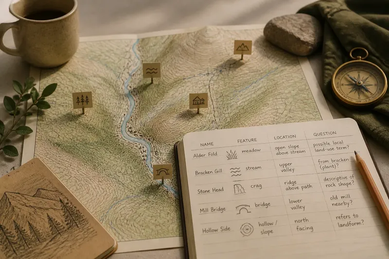
Use a topographic map or a digital map that clearly shows one valley and its labels. Pick a manageable area, such as the valley floor and one adjoining slope. A notebook or a simple table can hold four useful details: the name exactly as printed, the feature beside it, its location, and any question it raises. Preserve accents and unfamiliar spellings rather than silently correcting them.
Before sorting names, trace the main stream and note where the valley widens, narrows, or meets a side hollow. This gives you a sense of the terrain without turning the exercise into a study of routes or map coverage. Think of the labels like tags on jars in a pantry: they identify what someone chose to name, but they do not explain everything inside.
Sort names by what they appear to name
Group labels by feature, not by how important they seem. Useful groups include:
- Water: streams, springs, lakes, marshy ground, and waterfalls.
- Settlements: villages, farms, and named buildings or clusters.
- Land cover: forests, meadows, pastures, and open ground.
- Landforms: cliffs, hollows, ridges, peaks, and broad slopes.
- Built features: bridges, chapels, mills, and other structures.
Some labels point to a single feature; others may refer to a wider area. If a name sits between a stream and a hollow, record both as possibilities rather than pinning it to one object. The map’s typography is a clue to placement, not a formal boundary.
Read the words without turning guesses into facts
Look for words that seem to describe shape, color, plants, animals, or human use. Treat these as prompts for questions, not proof of a name’s origin. A term that looks familiar in English may have a different meaning in a regional language, and a spelling may reflect a standardized form rather than how local speakers say it.
Keep a simple distinction in your notes: “The label appears beside the upper meadow” is an observation; “the name means a place for summer grazing” is an interpretation that needs support beyond the map. If you want to investigate further, consult a reliable local gazetteer, historical map, or language resource, and note which source supports each explanation.
Notice language and memory in the labels
A valley can carry names in more than one language, and a map may print only one form. That choice can reflect an official spelling, a map’s audience, or a particular naming convention. It does not establish that other forms have vanished from local speech.
Imagine you are reading a map of a fictional valley called Alder Run. The map labels a meadow “Alder Fold,” but gives no explanation. You write down the exact spelling, note that it sits beside an open slope, and mark “possible local land-use term” as a question rather than a translation. The resulting note preserves a useful lead without pretending to know what residents mean by it.
How should you handle uncertain names?
Can a map label explain a name’s origin?
Usually, it cannot do so by itself. Treat a likely meaning as a question, then look for a dependable local or historical source before presenting it as an explanation.
Why might one place have more than one name?
Different languages, local speech, and official naming practices can produce distinct forms. Record the versions you encounter and where each appears instead of assuming one is the only valid name.
What does an unlabeled feature tell me?
Only that the map does not print a name there. It does not show whether people who know the valley use a name that the map leaves out.
How can I check an unfamiliar spelling?
Compare it with a local gazetteer, a historical map, or a source from the relevant language community. Keep the original map spelling in your notes and identify the source for any alternative form.
Make each observation lead to a careful decision
As you review your notes, decide what the map supports and what needs another source. Use this short check to keep the distinction clear:
- If a label sits directly beside a named stream, record the stream as the apparent feature; if its placement is ambiguous, note the stream and nearby hollow as alternatives.
- If a name resembles a familiar descriptive word, mark that as a possible reading; if the language or context is uncertain, leave its meaning open.
- If a feature has labels in multiple forms on your sources, preserve each form with its source; if only one map is available, do not claim that it is the sole local name.
- If a map leaves a meadow or slope unnamed, write “no label printed”; if you need to know whether people use another name, consult a local source.
- If several labels cluster around a settlement, note that concentration on this map; if you want to explain why, seek evidence beyond the pattern itself.
- If an old map and a current map spell a name differently, record both dates and spellings; if you cannot establish why they differ, describe the change without assigning a cause.
A place-name walk along a mountain valley is most useful when it leaves room for uncertainty. Finish with a few grounded observations about which names you can locate, which forms vary, and which meanings remain unanswered. The next time you see a valley’s labels, you will have a sharper sense of what the map says—and a clear boundary around what it cannot tell you.